Kirkcudbright Combination, Kirkcudbrightshire
Erected in 1849-50, the Kirkcudbright Combination poorhouse was initially set up by the combined parishes of Borgue, Kirkcudbright, Tongland and Twynholm. The Combination later expanded to include Anwoth, Balmaclellan, Balmaghie, Buittle, Carsphairn, Colvend, Crossmichael, Dalry, Girthon, Kells, Kelton, Kirkbean, Kirkmabreck, New Abbey, Parton, Rerrick, Troqueer, and Urr.
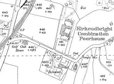
Designed by Jonathan A Bell of Edinburgh, the poorhouse was situated at "Nursery Ground" to the east of Kirkudbright. Its location and layout are shown on the 1908 OS map.

The poorhouse later became Burnside House. After 1930, its running was taken over by the county council's health department. In 1946, an official report described it as 'quite unsuitable for the housing and treatment of the sick, and is no place for the aged. It should be abandoned.' The building was demolished a few years afterwards and a housing estate now stands on the site.
Records
Note: many repositories impose a closure period of up to 100 years for records identifying individuals. Before travelling a long distance, always check that the records you want to consult will be available.
- Dumfries and Galloway Archives, 33 Burns Street, Dumfries DG1 2PS, Scotland. Poorhouse minutes (1848-1930); Records of applications (1883-1901, 1903-23, 1928-30).
Bibliography
- None.
Links
Unless otherwise indicated, this page () is copyright Peter Higginbotham. Contents may not be reproduced without permission.


